
Make a donation
Gear up for your next adventure:
As an Amazon Associate, this site earns from qualifying purchases at no extra cost to you.
Holly Hills topographic map
Click on the map to display elevation.
Make a donation
Gear up for your next adventure:
As an Amazon Associate, this site earns from qualifying purchases at no extra cost to you.
About this map
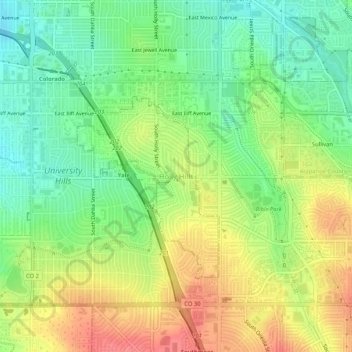
Name: Holly Hills topographic map, elevation, terrain.
Average elevation: 1,671 m
Minimum elevation: 1,640 m
Maximum elevation: 1,707 m
Make a donation
Gear up for your next adventure:
As an Amazon Associate, this site earns from qualifying purchases at no extra cost to you.
Other topographic maps
Click on a map to view its topography, its elevation and its terrain.
Arapahoe County Fairgrounds and Regional Park
United States > Colorado > Arapahoe County > Aurora
Average elevation: 1,783 m
Make a donation
Gear up for your next adventure:
As an Amazon Associate, this site earns from qualifying purchases at no extra cost to you.
Cherry Creek State Park
United States > Colorado > Arapahoe County > Greenwood Village
Average elevation: 1,713 m
Make a donation
Gear up for your next adventure:
As an Amazon Associate, this site earns from qualifying purchases at no extra cost to you.
Blackrock Lake
United States > Colorado > Arapahoe County > Littleton > Wolhurst
Average elevation: 1,649 m
Make a donation
Gear up for your next adventure:
As an Amazon Associate, this site earns from qualifying purchases at no extra cost to you.