Geolocate

Baguru topographic map

Click on the map to display elevation.

About this map

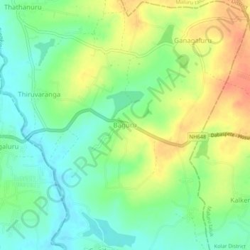
Name: Baguru topographic map, elevation, terrain.

Location: Baguru, Hosakote taluk, Bengaluru Rural, Karnataka, India (12.87664 77.82168 12.91664 77.86168)

Average elevation: 865 m

Minimum elevation: 845 m

Maximum elevation: 889 m

Gear up for your next adventure:

🥾Hiking Gaiters - Protect legs and shoes from mud, snow, and debris
🕶️Polarized Sunglasses - Reduces glare from snow and water at high elevations
🔭Compact Monocular - One-handed bird watching and trail spotting
👟Leg Gaiters - Keep debris, mud, and snow out of your boots
💡LED Headlamp - Hands-free illumination for night hiking and camping

As an Amazon Associate, this site earns from qualifying purchases at no extra cost to you.