
Make a donation
Gear up for your next adventure:
As an Amazon Associate, this site earns from qualifying purchases at no extra cost to you.
Kopaonik topographic map
Click on the map to display elevation.
Make a donation
Gear up for your next adventure:
As an Amazon Associate, this site earns from qualifying purchases at no extra cost to you.
Kopaonik
The national park is situated on a relatively flat region, at an altitude of about 1,700 m (5,577 ft). This central Kopaonik plateau is called Suvo Rudište. It is surrounded by mountain peaks. To the north and northwest of this plateau stretches Banjski Kopaonik, which is the location of Jošanička Banja spa, whose strong springs' waters reach the temperature of 88 °C (190 °F). Directly below the Suvo Rudište plateau starts the valley of the Samokovska River, with its steep run, numerous rapids, falls and gorges. Kopaonik has over 200 sunny days annually and over 160 days covered by snow. There is also the Jelovarnik falls, one of the highest in Serbia.
Make a donation
Gear up for your next adventure:
As an Amazon Associate, this site earns from qualifying purchases at no extra cost to you.
About this map
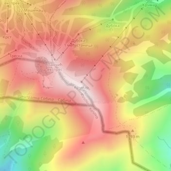
Name: Kopaonik topographic map, elevation, terrain.
Average elevation: 1,733 m
Minimum elevation: 1,334 m
Maximum elevation: 2,004 m
Make a donation
Gear up for your next adventure:
As an Amazon Associate, this site earns from qualifying purchases at no extra cost to you.
Other topographic maps
Click on a map to view its topography, its elevation and its terrain.
Brzece
Serbia > Central Serbia > Rasina Administrative District > Brus Municipality
Average elevation: 1,179 m