
Thank you for supporting this site ❤️
Make a donation
Make a donation
Gear up for your next adventure:
As an Amazon Associate, this site earns from qualifying purchases at no extra cost to you.
Kottingbrunn topographic map
Click on the map to display elevation.
Thank you for supporting this site ❤️
Make a donation
Make a donation
Gear up for your next adventure:
As an Amazon Associate, this site earns from qualifying purchases at no extra cost to you.
About this map
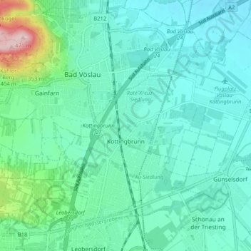
Name: Kottingbrunn topographic map, elevation, terrain.
Location: Kottingbrunn, Bezirk Baden, Lower Austria, 2542, Austria (47.93448 16.19708 47.97473 16.27653)
Average elevation: 262 m
Minimum elevation: 218 m
Maximum elevation: 465 m
Thank you for supporting this site ❤️
Make a donation
Make a donation
Gear up for your next adventure:
As an Amazon Associate, this site earns from qualifying purchases at no extra cost to you.
Other topographic maps
Click on a map to view its topography, its elevation and its terrain.
Matterhorn
Austria > Lower Austria > Bezirk Baden > Altenmarkt an der Triesting
Average elevation: 526 m