Geolocate

Union Furnace topographic map

Click on the map to display elevation.

About this map

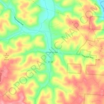
Name: Union Furnace topographic map, elevation, terrain.

Location: Union Furnace, Hocking County, Ohio, 43158, United States (39.44174 -82.37626 39.48174 -82.33626)

Average elevation: 268 m

Minimum elevation: 206 m

Maximum elevation: 318 m

Other topographic maps

Click on a map to view its topography, its elevation and its terrain.

Murray City

United States > Ohio > Hocking County

Average elevation: 257 m

Rose Lake

United States > Ohio > Hocking County

Average elevation: 295 m

Logan

United States > Ohio > Hocking County

Average elevation: 254 m

Rose Lake Dam

United States > Ohio > Hocking County

Average elevation: 297 m

Gear up for your next adventure:

🔋Lithium AA Batteries - Long-lasting power that performs in extreme cold
🧶550 Survival Paracord - Versatile utility cord for emergency repairs and rigging
🔦LED Flashlight - Powerful and long-lasting flashlight for camping and emergencies
🩹Compact First Aid Kit - Pre-packed essentials for common trail injuries
Lightweight Backpacking Tent - Compact tent for efficient hiking trips

As an Amazon Associate, this site earns from qualifying purchases at no extra cost to you.