
Nyúl topographic map
Interactive map
Click on the map to display elevation.
About this map
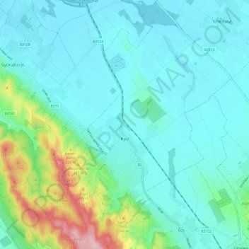
Name: Nyúl topographic map, elevation, terrain.
Average elevation: 151 m
Minimum elevation: 113 m
Maximum elevation: 316 m
Other topographic maps
Click on a map to view its topography, its elevation and its terrain.
Pannonhalma
Hungría > Győr-Moson-Sopron vármegye
Pannonhalma, Pannonhalmi járás, Győr-Moson-Sopron vármegye, Transdanubio Occidental, Transdanubia, 9090, Hungría
Average elevation: 172 m
Ravazd
Hungría > Győr-Moson-Sopron vármegye
Ravazd, Pannonhalmi járás, Győr-Moson-Sopron vármegye, Transdanubio Occidental, Transdanubia, 9091, Hungría
Average elevation: 207 m
Lila-hegy
Hungría > Győr-Moson-Sopron vármegye > Győrújbarát
Lila-hegy, Győrújbarát, Győri járás, Győr-Moson-Sopron vármegye, Transdanubio Occidental, Transdanubia, 9082, Hungría
Average elevation: 217 m
Nyúlhegy
Hungría > Győr-Moson-Sopron vármegye > Nyúl
Nyúlhegy, Nyúl, Győri járás, Győr-Moson-Sopron vármegye, Transdanubio Occidental, Transdanubia, 9082, Hungría
Average elevation: 192 m
Győr
Hungría > Győr-Moson-Sopron vármegye
Győr, Győri járás, Győr-Moson-Sopron vármegye, Transdanubio Occidental, Transdanubia, Hungría
Average elevation: 120 m