
Anchuruli topographic map
Click on the map to display elevation.
About this map
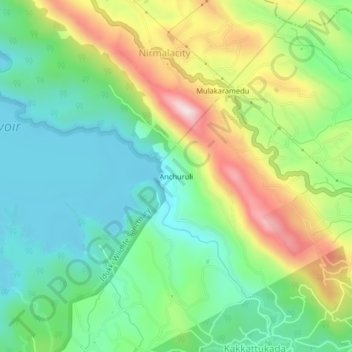
Name: Anchuruli topographic map, elevation, terrain.
Location: Anchuruli, Idukki, Idukki District, Kerala, 685511, India (9.74943 77.05628 9.78943 77.09628)
Average elevation: 880 m
Minimum elevation: 712 m
Maximum elevation: 1,193 m
Other topographic maps
Click on a map to view its topography, its elevation and its terrain.
Shaji A M Ayyamvellil,Kattapana South Kulam
India > Kerala > Idukki > Kattappana
Average elevation: 909 m
Shaji A M Ayyamvellil,Kattapana South Kulam
India > Kerala > Idukki > Kattappana
Average elevation: 909 m