
Make a donation
Gear up for your next adventure:
As an Amazon Associate, this site earns from qualifying purchases at no extra cost to you.
Hochmössingen topographic map
Click on the map to display elevation.
Make a donation
Gear up for your next adventure:
As an Amazon Associate, this site earns from qualifying purchases at no extra cost to you.
About this map
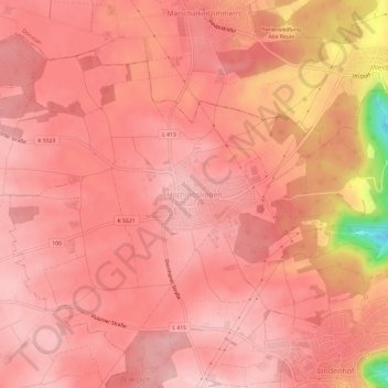
Name: Hochmössingen topographic map, elevation, terrain.
Average elevation: 657 m
Minimum elevation: 490 m
Maximum elevation: 697 m
Make a donation
Gear up for your next adventure:
As an Amazon Associate, this site earns from qualifying purchases at no extra cost to you.
Other topographic maps
Click on a map to view its topography, its elevation and its terrain.
78727
Deutschland > Baden-Württemberg > Landkreis Rottweil > Oberndorf am Neckar
Average elevation: 574 m
Hochmössingen
Deutschland > Baden-Württemberg > Landkreis Rottweil > Oberndorf am Neckar
Average elevation: 656 m
Einfeld
Deutschland > Baden-Württemberg > Landkreis Rottweil > Oberndorf am Neckar > Einfeld
Average elevation: 570 m
Kälberhalde
Deutschland > Baden-Württemberg > Landkreis Rottweil > Oberndorf am Neckar
Average elevation: 559 m
Make a donation
Gear up for your next adventure:
As an Amazon Associate, this site earns from qualifying purchases at no extra cost to you.
Hochmössingen
Deutschland > Baden-Württemberg > Landkreis Rottweil > Oberndorf am Neckar
Average elevation: 656 m