Geolocate

Puncha topographic map

Click on the map to display elevation.

About this map

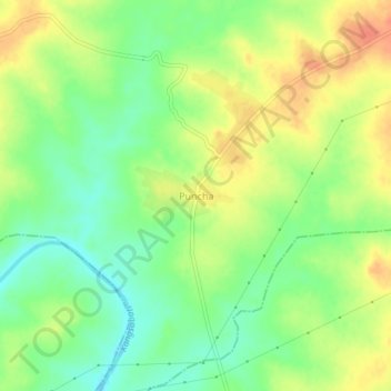
Name: Puncha topographic map, elevation, terrain.

Location: Puncha, Purulia, West Bengal, 723151, India (23.13849 86.63058 23.17849 86.67058)

Average elevation: 171 m

Minimum elevation: 149 m

Maximum elevation: 194 m

Gear up for your next adventure:

🔦LED Flashlight - Powerful and long-lasting flashlight for camping and emergencies
🛏️Camping Sleeping Mat - Comfortable mats for sleeping outdoors
🧰Multitool Knife - Compact and versatile tool for outdoor use
🧴Outdoor Sunscreen - High SPF protection for high-altitude UV exposure
🧥Waterproof Hiking Jacket - Protect yourself from rain and wind while hiking

As an Amazon Associate, this site earns from qualifying purchases at no extra cost to you.