Geolocate

Bethesda topographic map

Click on the map to display elevation.

About this map

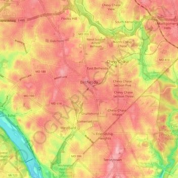
Name: Bethesda topographic map, elevation, terrain.

Location: Bethesda, Montgomery County, Maryland, United States (38.94040 -77.15856 39.02242 -77.07716)

Average elevation: 81 m

Minimum elevation: 4 m

Maximum elevation: 129 m

Gear up for your next adventure:

🥾Trail Running Shoes - Lightweight and durable shoes for trail running
🧢Outdoor Cap - Protective cap for sun and rain during hikes
Camping Essentials - All-in-one gear for a comfortable camping trip
🧥Ultralight Puffy Jacket - Maximum warmth that packs down to the size of an orange
🔪Outdoor Multitool - Versatile tool for repairs and food prep in the wild

As an Amazon Associate, this site earns from qualifying purchases at no extra cost to you.