Geolocate

Annapolis topographic map

Click on the map to display elevation.

About this map

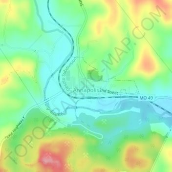
Name: Annapolis topographic map, elevation, terrain.

Location: Annapolis, Iron County, Missouri, United States (37.35632 -90.70596 37.36554 -90.68711)

Average elevation: 222 m

Minimum elevation: 181 m

Maximum elevation: 295 m

Other topographic maps

Click on a map to view its topography, its elevation and its terrain.

Belleview

United States > Missouri > Iron County

Average elevation: 328 m

Stony Mountain

United States > Missouri > Iron County

Average elevation: 268 m

Russellville

United States > Missouri > Iron County > Arcadia

Average elevation: 299 m

Gear up for your next adventure:

🥾Hiking Shorts - Breathable shorts suitable for summer hikes
🧰Emergency Multi-Tool - Compact multi-tool for outdoor survival
Family Camping Tent - Spacious tent suitable for family camping trips
💡Compact LED Flashlight - Powerful and portable flashlight for outdoor use
🔋Emergency Crank Radio - Weather alerts and power without needing batteries

As an Amazon Associate, this site earns from qualifying purchases at no extra cost to you.