
Make a donation
Gear up for your next adventure:
As an Amazon Associate, this site earns from qualifying purchases at no extra cost to you.
Paruthumpara topographic map
Click on the map to display elevation.
Make a donation
Gear up for your next adventure:
As an Amazon Associate, this site earns from qualifying purchases at no extra cost to you.
About this map
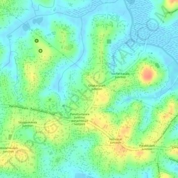
Name: Paruthumpara topographic map, elevation, terrain.
Location: Paruthumpara, Kottayam, Kerala, India (9.52765 76.53839 9.54066 76.54552)
Average elevation: 19 m
Minimum elevation: -5 m
Maximum elevation: 50 m
Make a donation
Gear up for your next adventure:
As an Amazon Associate, this site earns from qualifying purchases at no extra cost to you.
Other topographic maps
Click on a map to view its topography, its elevation and its terrain.
Kottayam
Kottayam has an average elevation of 3 metres (9.8 ft) above sea level. and is situated in the basin of the Meenachil River and in the basin of the Vembanad backwaters, which are formed from several streams in the Western Ghats in Idukki district. According to the division of places in Kerala based on…
Average elevation: 19 m
Make a donation
Gear up for your next adventure:
As an Amazon Associate, this site earns from qualifying purchases at no extra cost to you.
Make a donation
Gear up for your next adventure:
As an Amazon Associate, this site earns from qualifying purchases at no extra cost to you.