
Make a donation
Gear up for your next adventure:
As an Amazon Associate, this site earns from qualifying purchases at no extra cost to you.
Sara topographic map
Click on the map to display elevation.
Make a donation
Gear up for your next adventure:
As an Amazon Associate, this site earns from qualifying purchases at no extra cost to you.
Sara
Se encuentra a una altitud media de 289 msnm. Tiene una temperatura media de 24,5 °C y una precipitación pluvial media 1 535,50 mm al año.
Make a donation
Gear up for your next adventure:
As an Amazon Associate, this site earns from qualifying purchases at no extra cost to you.
About this map
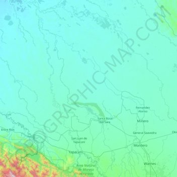
Name: Sara topographic map, elevation, terrain.
Location: Sara, Santa Cruz, Bolivia (-17.63339 -64.33548 -16.00048 -63.19690)
Average elevation: 269 m
Minimum elevation: 168 m
Maximum elevation: 2,455 m
Make a donation
Gear up for your next adventure:
As an Amazon Associate, this site earns from qualifying purchases at no extra cost to you.
Other topographic maps
Click on a map to view its topography, its elevation and its terrain.