Puck County topographic map
Interactive map
Click on the map to display elevation.
About this map
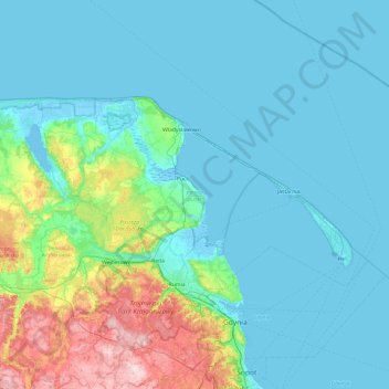
Name: Puck County topographic map, elevation, terrain.
Location: Puck County, Pomeranian Voivodeship, Poland (54.55738 17.91143 54.83642 18.82886)
Average elevation: 44 m
Minimum elevation: -4 m
Maximum elevation: 235 m
Other topographic maps
Click on a map to view its topography, its elevation and its terrain.
Sławoszyno
Poland > Pomeranian Voivodeship > Puck County
Sławoszyno, gmina Krokowa, Puck County, Pomeranian Voivodeship, 84-110, Poland
Average elevation: 23 m
Sławutowo
Poland > Pomeranian Voivodeship > Puck County
Sławutowo, gmina Puck, Puck County, Pomeranian Voivodeship, 84-122, Poland
Average elevation: 51 m
Władysławowo
Poland > Pomeranian Voivodeship > Puck County
Władysławowo, Puck County, Pomeranian Voivodeship, Poland
Average elevation: 11 m
Kartoszyno
Poland > Pomeranian Voivodeship > Puck County
Kartoszyno, gmina Krokowa, Puck County, Pomeranian Voivodeship, 84-110, Poland
Average elevation: 36 m
Żelistrzewo
Poland > Pomeranian Voivodeship > Puck County
Żelistrzewo, gmina Puck, Puck County, Pomeranian Voivodeship, 84-122, Poland
Average elevation: 25 m