
Make a donation
Gear up for your next adventure:
As an Amazon Associate, this site earns from qualifying purchases at no extra cost to you.
Venustiano Carranza topographic map
Click on the map to display elevation.
Make a donation
Gear up for your next adventure:
As an Amazon Associate, this site earns from qualifying purchases at no extra cost to you.
Venustiano Carranza
Se encuentra a una altitud de 2,240 metros sobre el nivel del mar. Tiene un clima semiseco templado, con una temperatura media anual de 16° centígrados y precipitación pluvial de 600 mm anuales.
Make a donation
Gear up for your next adventure:
As an Amazon Associate, this site earns from qualifying purchases at no extra cost to you.
About this map
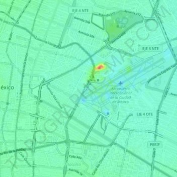
Name: Venustiano Carranza topographic map, elevation, terrain.
Location: Venustiano Carranza, Ciudad de México, 15900, México (19.40433 -99.12820 19.45977 -99.04646)
Average elevation: 2,232 m
Minimum elevation: 2,220 m
Maximum elevation: 2,274 m
Make a donation
Gear up for your next adventure:
As an Amazon Associate, this site earns from qualifying purchases at no extra cost to you.
Other topographic maps
Click on a map to view its topography, its elevation and its terrain.
Tlalpan
De este modo, el clima varía de templado subhúmedo en la parte Norte a semifrío subhúmedo conforme aumenta la altitud hasta tornarse semifrío húmedo en las partes más altas.
Average elevation: 2,291 m
Make a donation
Gear up for your next adventure:
As an Amazon Associate, this site earns from qualifying purchases at no extra cost to you.