
Make a donation
Gear up for your next adventure:
As an Amazon Associate, this site earns from qualifying purchases at no extra cost to you.
Kadiri topographic map
Click on the map to display elevation.
Make a donation
Gear up for your next adventure:
As an Amazon Associate, this site earns from qualifying purchases at no extra cost to you.
Kadiri
Kadiri is located at 78.170 degrees E longitude and 14.120 degrees N latitude and has an average elevation of 504.00 meters (1653 feet) above MSL. Kadiri is surrounded by hill on the north and east.
Make a donation
Gear up for your next adventure:
As an Amazon Associate, this site earns from qualifying purchases at no extra cost to you.
About this map
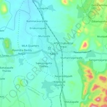
Name: Kadiri topographic map, elevation, terrain.
Location: Kadiri, Sri Sathya Sai, Andhra Pradesh, 515591, India (14.06823 78.12107 14.14823 78.20107)
Average elevation: 550 m
Minimum elevation: 487 m
Maximum elevation: 850 m
Make a donation
Gear up for your next adventure:
As an Amazon Associate, this site earns from qualifying purchases at no extra cost to you.