
Monte Catillo topographic map
Click on the map to display elevation.
About this map
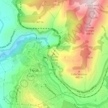
Name: Monte Catillo topographic map, elevation, terrain.
Location: Monte Catillo, Tivoli, Roma Capitale, Lazio, 00019, Italy (41.96493 12.80557 41.96503 12.80567)
Average elevation: 284 m
Minimum elevation: 54 m
Maximum elevation: 588 m
Other topographic maps
Click on a map to view its topography, its elevation and its terrain.
Villa d'Este
Italy > Lazio > Roma Capitale > Tivoli
Tivoli had been a popular summer residence since ancient Roman times due to its altitude, cooler temperatures and its proximity to the Villa Hadriana, the summer residence of the Emperor Hadrian I. The position of Governor of Tivoli came with an official residence located in a former convent of the Benedictine…
Average elevation: 203 m