
Thank you for supporting this site ❤️
Make a donation
Make a donation
Gear up for your next adventure:
As an Amazon Associate, this site earns from qualifying purchases at no extra cost to you.
O Castro da Virxe topographic map
Click on the map to display elevation.
Thank you for supporting this site ❤️
Make a donation
Make a donation
Gear up for your next adventure:
As an Amazon Associate, this site earns from qualifying purchases at no extra cost to you.
About this map
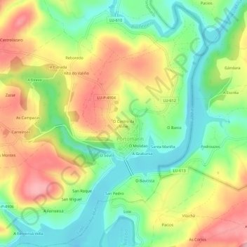
Name: O Castro da Virxe topographic map, elevation, terrain.
Location: O Castro da Virxe, Portomarín, Lugo, Galice, 21170, Espagne (42.79061 -7.63702 42.83061 -7.59702)
Average elevation: 398 m
Minimum elevation: 325 m
Maximum elevation: 492 m
Thank you for supporting this site ❤️
Make a donation
Make a donation
Gear up for your next adventure:
As an Amazon Associate, this site earns from qualifying purchases at no extra cost to you.
Other topographic maps
Click on a map to view its topography, its elevation and its terrain.