
Make a donation
Gear up for your next adventure:
As an Amazon Associate, this site earns from qualifying purchases at no extra cost to you.
Salomonsborn topographic map
Click on the map to display elevation.
Make a donation
Gear up for your next adventure:
As an Amazon Associate, this site earns from qualifying purchases at no extra cost to you.
About this map
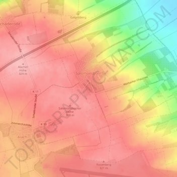
Name: Salomonsborn topographic map, elevation, terrain.
Location: Salomonsborn, Erfurt, Thüringen, Deutschland (50.97979 10.92735 51.01298 10.97279)
Average elevation: 290 m
Minimum elevation: 199 m
Maximum elevation: 330 m
Make a donation
Gear up for your next adventure:
As an Amazon Associate, this site earns from qualifying purchases at no extra cost to you.
Other topographic maps
Click on a map to view its topography, its elevation and its terrain.
Marbach
Deutschland > Thüringen > Erfurt
Der Ort befindet sich im Westen von Erfurt. Westlich von Marbach liegt auf einer Anhöhe der Erfurter Stadtteil Salomonsborn. Im Süden erstreckt sich eines der größten Kleingartengebiete Erfurts. Östlich und nördlich der Ortslage sind Ackerflächen und die Bundesstraße B 4. Durch den Ort fließt der…
Average elevation: 225 m