Geolocate

Sturgis topographic map

Click on the map to display elevation.

About this map

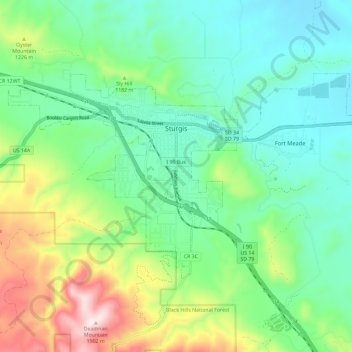
Name: Sturgis topographic map, elevation, terrain.

Location: Sturgis, Meade County, South Dakota, United States (44.37906 -103.56459 44.43219 -103.36348)

Average elevation: 1,136 m

Minimum elevation: 934 m

Maximum elevation: 1,630 m

Gear up for your next adventure:

🧭GPS Tracker - Track your location in remote areas safely
Camping Essentials - All-in-one gear for a comfortable camping trip
🗺️Topographic Maps - Detailed maps to explore trails, mountains, and wilderness areas
🧢Outdoor Visor - Breathable visor for sunny hikes
🕯️Camping Lantern - Illuminates your entire campsite with high-efficiency LEDs

As an Amazon Associate, this site earns from qualifying purchases at no extra cost to you.