
Make a donation
Gear up for your next adventure:
As an Amazon Associate, this site earns from qualifying purchases at no extra cost to you.
Dermsdorf topographic map
Click on the map to display elevation.
Make a donation
Gear up for your next adventure:
As an Amazon Associate, this site earns from qualifying purchases at no extra cost to you.
Dermsdorf
Im Jahr 2011 gab es den archäologisch bedeutenden Depotfund von Dermsdorf: Beim Bau der Ortsumgehung fand man auf einer Fläche von 7000 m² Pfosten, Abfallgruben und Gräber der frühen Bronzezeit (ca. 2000–1700 v. Chr.) und aus dem Mittelalter (8.–11. Jahrhundert). Herausragend war dabei ein Depot von rund 100 Bronzebeilen in einem Tongefäß. Diese waren an der Giebelseite eines Hauses aus der frühen Bronzezeit vergraben. Mit 44 Metern Länge gilt es als eines der größten bekannten urgeschichtlichen Gebäude Mitteldeutschlands. Es stand auf einer Anhöhe in Sichtweite des bronzezeitlichen Fürstengrabes von Leubingen.
Make a donation
Gear up for your next adventure:
As an Amazon Associate, this site earns from qualifying purchases at no extra cost to you.
About this map
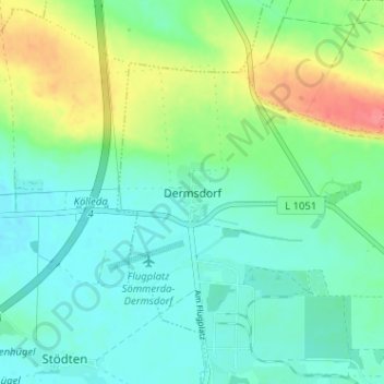
Name: Dermsdorf topographic map, elevation, terrain.
Average elevation: 152 m
Minimum elevation: 133 m
Maximum elevation: 196 m
Make a donation
Gear up for your next adventure:
As an Amazon Associate, this site earns from qualifying purchases at no extra cost to you.
Other topographic maps
Click on a map to view its topography, its elevation and its terrain.
Beichlingen
Deutschland > Thüringen > Landkreis Sömmerda > Kölleda
Stadtteil: Kiebitzhöhe
Average elevation: 217 m
Großmonra
Deutschland > Thüringen > Landkreis Sömmerda > Kölleda
Stadtteil: Kiebitzhöhe
Average elevation: 240 m