Geolocate

Yesa topographic map

Click on the map to display elevation.

About this map

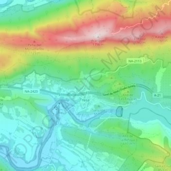
Name: Yesa topographic map, elevation, terrain.

Location: Yesa, Zangozerria / Comarca de Sangüesa, Spain (42.60313 -1.24350 42.64851 -1.15382)

Average elevation: 690 m

Minimum elevation: 408 m

Maximum elevation: 1,346 m

Gear up for your next adventure:

🎒Backpack Rain Cover - External shield to keep your entire pack dry
🎒Fully Waterproof Backpack - Total protection for photography gear and electronics
🦌Outdoor Trail Camera - Monitor wildlife activity near your favorite spots
💡Solar Camping Lamp - Eco-friendly lighting for campsites
🔋Emergency Crank Radio - Weather alerts and power without needing batteries

As an Amazon Associate, this site earns from qualifying purchases at no extra cost to you.