
Make a donation
Gear up for your next adventure:
As an Amazon Associate, this site earns from qualifying purchases at no extra cost to you.
Satzvey topographic map
Click on the map to display elevation.
Make a donation
Gear up for your next adventure:
As an Amazon Associate, this site earns from qualifying purchases at no extra cost to you.
Satzvey
Vom 11. August 1895 bis 31. Dezember 1965 führte durch Satzvey die sogenannte „Eifelstrecke“ der Euskirchener Kreisbahnen, die dort die Eifelbahn Köln – Trier höhengleich kreuzte. Ferner hat Satzvey einen eigenen Bahnhof an ebendieser Eifelbahn, der von RB-Zügen Köln – Kall bedient wird.
Make a donation
Gear up for your next adventure:
As an Amazon Associate, this site earns from qualifying purchases at no extra cost to you.
About this map
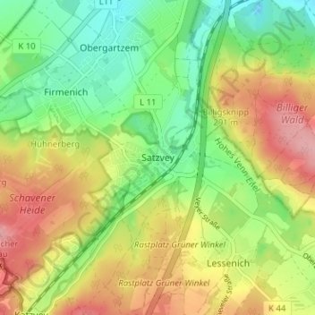
Name: Satzvey topographic map, elevation, terrain.
Average elevation: 248 m
Minimum elevation: 192 m
Maximum elevation: 317 m
Make a donation
Gear up for your next adventure:
As an Amazon Associate, this site earns from qualifying purchases at no extra cost to you.
Other topographic maps
Click on a map to view its topography, its elevation and its terrain.
Angelteiche Feyermühle
Deutschland > Nordrhein-Westfalen > Kreis Euskirchen > Mechernich > Breitenbenden > Burgfey
Average elevation: 312 m
Bescheid
Deutschland > Nordrhein-Westfalen > Kreis Euskirchen > Mechernich > Bleibuir
Average elevation: 366 m