
Make a donation
Gear up for your next adventure:
As an Amazon Associate, this site earns from qualifying purchases at no extra cost to you.
Trippstadt topographic map
Click on the map to display elevation.
Make a donation
Gear up for your next adventure:
As an Amazon Associate, this site earns from qualifying purchases at no extra cost to you.
Trippstadt
Trippstadt liegt im Herzen des Pfälzerwaldes 15 Straßenkilometer südlich von Kaiserslautern im Biosphärenreservat Pfälzerwald-Vosges du Nord. Der Südosten der Gemarkung ist Teil des Pfälzischen Holzlandes, das in östlicher Richtung in die Frankenweide übergeht. Der Ort selbst liegt auf einer Höhe von etwa 406 m ü. NHN. Nachbargemeinden sind – im Uhrzeigersinn – Kaiserslautern, Elmstein, Wilgartswiesen, Leimen, Heltersberg, Schmalenberg, Schopp und Stelzenberg.
Make a donation
Gear up for your next adventure:
As an Amazon Associate, this site earns from qualifying purchases at no extra cost to you.
About this map
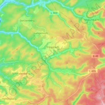
Name: Trippstadt topographic map, elevation, terrain.
Average elevation: 405 m
Minimum elevation: 278 m
Maximum elevation: 578 m
Make a donation
Gear up for your next adventure:
As an Amazon Associate, this site earns from qualifying purchases at no extra cost to you.
Other topographic maps
Click on a map to view its topography, its elevation and its terrain.
Schweinstal
Deutschland > Rheinland-Pfalz > Landkreis Kaiserslautern > Krickenbach
Average elevation: 349 m
Althütterhof
Deutschland > Rheinland-Pfalz > Landkreis Kaiserslautern > Otterberg
Average elevation: 307 m
Stüterhof
Deutschland > Rheinland-Pfalz > Landkreis Kaiserslautern > Waldleiningen
Average elevation: 428 m
Kreuzberg
Deutschland > Rheinland-Pfalz > Landkreis Kaiserslautern > Oberarnbach
Average elevation: 399 m
Make a donation
Gear up for your next adventure:
As an Amazon Associate, this site earns from qualifying purchases at no extra cost to you.
Lauerhof
Deutschland > Rheinland-Pfalz > Landkreis Kaiserslautern > Otterberg
Average elevation: 296 m
Weinbrunnerhof
Deutschland > Rheinland-Pfalz > Landkreis Kaiserslautern > Otterberg > Weinbrunnerhof
Average elevation: 319 m
Hirschhorner Bordenmühle
Deutschland > Rheinland-Pfalz > Landkreis Kaiserslautern > Sulzbachtal > Hirschhorner Bordenmühle
Average elevation: 262 m
Make a donation
Gear up for your next adventure:
As an Amazon Associate, this site earns from qualifying purchases at no extra cost to you.
Kaulbach
Deutschland > Rheinland-Pfalz > Landkreis Kaiserslautern > Reichenbach-Steegen
Average elevation: 328 m