
Thank you for supporting this site ❤️
Make a donation
Make a donation
Gear up for your next adventure:
As an Amazon Associate, this site earns from qualifying purchases at no extra cost to you.
Gülderen topographic map
Click on the map to display elevation.
Thank you for supporting this site ❤️
Make a donation
Make a donation
Gear up for your next adventure:
As an Amazon Associate, this site earns from qualifying purchases at no extra cost to you.
About this map
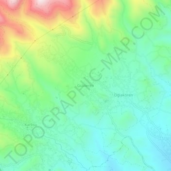
Name: Gülderen topographic map, elevation, terrain.
Location: Gülderen, Antakya, Hatay, Mediterranean Region, 31027, Turkey (36.26654 36.10335 36.30654 36.14335)
Average elevation: 368 m
Minimum elevation: 180 m
Maximum elevation: 808 m
Thank you for supporting this site ❤️
Make a donation
Make a donation
Gear up for your next adventure:
As an Amazon Associate, this site earns from qualifying purchases at no extra cost to you.