
Make a donation
Gear up for your next adventure:
As an Amazon Associate, this site earns from qualifying purchases at no extra cost to you.
Sheep Mountain Table topographic map
Click on the map to display elevation.
Make a donation
Gear up for your next adventure:
As an Amazon Associate, this site earns from qualifying purchases at no extra cost to you.
About this map
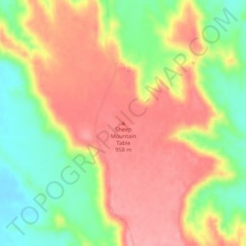
Name: Sheep Mountain Table topographic map, elevation, terrain.
Average elevation: 922 m
Minimum elevation: 857 m
Maximum elevation: 975 m
Make a donation
Gear up for your next adventure:
As an Amazon Associate, this site earns from qualifying purchases at no extra cost to you.
Other topographic maps
Click on a map to view its topography, its elevation and its terrain.
Rapid City
United States > South Dakota > Pennington County
Rapid City is located at 44°04′34″N 103°13′42″W / 44.076188°N 103.228299°W / 44.076188; -103.228299. The downtown elevation of Rapid City is 3,202 feet (976 m). Rapid City is located in the shadow of Black Elk Peak, which at 7,242 feet (2,207 m), is the highest point east of the Rocky Mountains.
Average elevation: 1,068 m
Mount Rushmore National Memorial
United States > South Dakota > Pennington County
The Mount Rushmore National Memorial is a national memorial centered on a colossal sculpture carved into the granite face of Mount Rushmore (Lakota: Tȟuŋkášila Šákpe, or Six Grandfathers) in the Black Hills near Keystone, South Dakota, United States. Sculptor Gutzon Borglum designed the sculpture, called…
Average elevation: 1,528 m
Make a donation
Gear up for your next adventure:
As an Amazon Associate, this site earns from qualifying purchases at no extra cost to you.
Rapid City
United States > South Dakota > Pennington County
Rapid City is located at 44°04′34″N 103°13′42″W / 44.076188°N 103.228299°W / 44.076188; -103.228299. The downtown elevation of Rapid City is 3,202 feet (976 m). Rapid City is located in the shadow of Black Elk Peak, which at 7,242 feet (2,207 m), is the highest point east of the Rocky Mountains.
Average elevation: 1,067 m
Make a donation
Gear up for your next adventure:
As an Amazon Associate, this site earns from qualifying purchases at no extra cost to you.
Rapid City
United States > South Dakota > Pennington County
Rapid City is located at 44°04′34″N 103°13′42″W / 44.076188°N 103.228299°W / 44.076188; -103.228299. The downtown elevation of Rapid City is 3,202 feet (976 m). Rapid City is located in the shadow of Black Elk Peak, which at 7,242 feet (2,207 m), is the highest point east of the Rocky Mountains.
Average elevation: 1,068 m
Make a donation
Gear up for your next adventure:
As an Amazon Associate, this site earns from qualifying purchases at no extra cost to you.
Mount Rushmore National Memorial
United States > South Dakota > Pennington County
Mount Rushmore National Memorial is a national memorial centered on a colossal sculpture carved into the granite face of Mount Rushmore (Lakota: Tȟuŋkášila Šákpe, or Six Grandfathers) in the Black Hills near Keystone, South Dakota, United States. Sculptor Gutzon Borglum created the sculpture's design and…
Average elevation: 1,528 m