Geolocate

Pelayangan topographic map

Click on the map to display elevation.

About this map

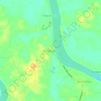
Name: Pelayangan topographic map, elevation, terrain.

Location: Pelayangan, Batanghari, Jambi, Sumatra, Indonesia (-1.72184 103.19721 -1.68184 103.23721)

Average elevation: 19 m

Minimum elevation: 7 m

Maximum elevation: 35 m

Other topographic maps

Click on a map to view its topography, its elevation and its terrain.

Sungai Lingkar

Indonesia > Jambi > Batanghari > Rawa Mekar

Average elevation: 29 m

Sungai Air Putih

Indonesia > Jambi > Batanghari

Average elevation: 31 m

Sungai Lalang

Indonesia > Jambi > Batanghari

Average elevation: 43 m

Gear up for your next adventure:

🧼Biodegradable Camp Soap - Environmentally friendly cleaning for gear and body
🥾Trail Hiking Shoes - Durable shoes designed for rugged trails
🪜Heavy Duty Carabiners - Multi-use clips for securing gear to your backpack
🥾Hiking Shoes - Durable and comfortable shoes for trail hiking
💡Solar Camping Lamp - Eco-friendly lighting for campsites

As an Amazon Associate, this site earns from qualifying purchases at no extra cost to you.