
Thank you for supporting this site ❤️
Make a donation
Make a donation
Gear up for your next adventure:
As an Amazon Associate, this site earns from qualifying purchases at no extra cost to you.
Pangururan topographic map
Click on the map to display elevation.
Thank you for supporting this site ❤️
Make a donation
Make a donation
Gear up for your next adventure:
As an Amazon Associate, this site earns from qualifying purchases at no extra cost to you.
About this map
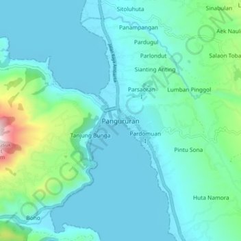
Name: Pangururan topographic map, elevation, terrain.
Location: Pangururan, Samosir, North Sumatra, Sumatra, 22392, Indonesia (2.56746 98.65593 2.64746 98.73593)
Average elevation: 1,052 m
Minimum elevation: 894 m
Maximum elevation: 1,911 m
Thank you for supporting this site ❤️
Make a donation
Make a donation
Gear up for your next adventure:
As an Amazon Associate, this site earns from qualifying purchases at no extra cost to you.
Other topographic maps
Click on a map to view its topography, its elevation and its terrain.
Kelurahan parhusip III Kecamatan Nainggolan
Indonesia > North Sumatra > Samosir
Average elevation: 914 m