Geolocate

Kingston topographic map

Click on the map to display elevation.

About this map

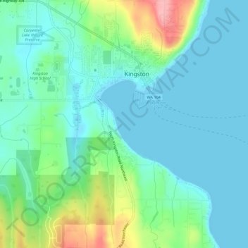
Name: Kingston topographic map, elevation, terrain.

Location: Kingston, Kitsap County, Washington, 98346, United States (47.77318 -122.52537 47.80954 -122.48739)

Average elevation: 30 m

Minimum elevation: 0 m

Maximum elevation: 126 m

Gear up for your next adventure:

🥾Trekking Poles - Adjustable trekking poles to reduce knee stress and improve stability
🩹Moleskin Blister Pads - Direct protection for painful foot pressure points
🥾Trail Hiking Boots - Supportive boots for rough trails
🥾Hiking Shoes - Durable and comfortable shoes for trail hiking
🥾Waterproof Hiking Shoes - Durable shoes for wet and rugged trails

As an Amazon Associate, this site earns from qualifying purchases at no extra cost to you.