Geolocate

Solodiran topographic map

Click on the map to display elevation.

About this map

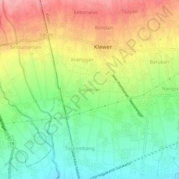
Name: Solodiran topographic map, elevation, terrain.

Location: Solodiran, Klaten, Central Java, Java, 57485, Indonesia (-7.72552 110.47042 -7.68552 110.51042)

Average elevation: 243 m

Minimum elevation: 185 m

Maximum elevation: 314 m

Other topographic maps

Click on a map to view its topography, its elevation and its terrain.

Sanggrahan

Indonesia > Central Java > Klaten

Average elevation: 150 m

Sungai

Indonesia > Central Java > Klaten > Nanggulan

Average elevation: 113 m

Gear up for your next adventure:

🚲Heavy Duty Bike Lock - Secure your bike at the trailhead or during stops
🛶Waterproof Dry Bags - Keep electronics and clothes dry during river crossings
💧Hydration Bladder - Hands-free hydration solution for long treks
🧳Compression Sacks - Maximize space in your backpack by shrinking gear
🛌Insulated Sleeping Pad - Critical thermal barrier between you and the cold ground

As an Amazon Associate, this site earns from qualifying purchases at no extra cost to you.