Geolocate

Moira topographic map

Click on the map to display elevation.

About this map

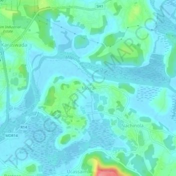
Name: Moira topographic map, elevation, terrain.

Location: Moira, Bardez, North Goa, Goa, 403508, India (15.58052 73.82411 15.62052 73.86411)

Average elevation: 14 m

Minimum elevation: -3 m

Maximum elevation: 86 m

Other topographic maps

Click on a map to view its topography, its elevation and its terrain.

Anjuna

India > Goa > Bardez

Average elevation: 13 m

Anjuna

India > Goa > Bardez > Anjuna

Average elevation: 14 m

Pilerne Lake

India > Goa > Bardez > Sangolda

Average elevation: 39 m

Corjuem Fort

India > Goa > Bardez > Corjuem

Average elevation: 13 m

Aguada Fort

India > Goa > Bardez > Sinquerim

Average elevation: 8 m

Anjuna Beach

India > Goa > Bardez > Anjuna

Average elevation: 10 m

Chapora Fort

India > Goa > Bardez > Chapora

Average elevation: 8 m

Gear up for your next adventure:

🧢Hiking Hat - Sun-protective and breathable hats for long treks
💧Hydration Pack - Hands-free hydration system for long hikes
🥾Trail Running Boots - Durable shoes designed for trail running
🪑Ultralight Camping Stool - Compact seating for rest stops during long hikes
🥾Trekking Poles - Adjustable trekking poles to reduce knee stress and improve stability

As an Amazon Associate, this site earns from qualifying purchases at no extra cost to you.