
Make a donation
Gear up for your next adventure:
As an Amazon Associate, this site earns from qualifying purchases at no extra cost to you.
Val-des-Bois topographic map
Click on the map to display elevation.
Make a donation
Gear up for your next adventure:
As an Amazon Associate, this site earns from qualifying purchases at no extra cost to you.
About this map
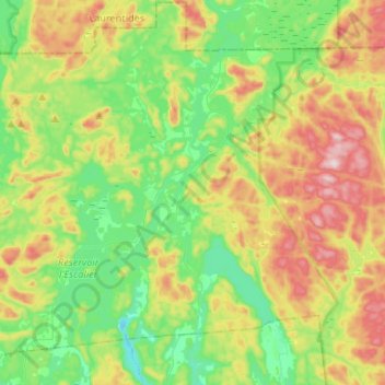
Name: Val-des-Bois topographic map, elevation, terrain.
Location: Val-des-Bois, Papineau, Outaouais, Quebec, J0X 3C0, Canada (45.83392 -75.65577 45.97323 -75.39237)
Average elevation: 271 m
Minimum elevation: 131 m
Maximum elevation: 516 m
Papineau trails, hiking, mountain biking, running and outdoor activities
Make a donation
Gear up for your next adventure:
As an Amazon Associate, this site earns from qualifying purchases at no extra cost to you.
Other topographic maps
Click on a map to view its topography, its elevation and its terrain.
Make a donation
Gear up for your next adventure:
As an Amazon Associate, this site earns from qualifying purchases at no extra cost to you.
Réserve écologique de la Forêt-la-Blanche
Canada > Quebec > Papineau > Mulgrave-et-Derry
Average elevation: 243 m