Geolocate

Hucking topographic map

Click on the map to display elevation.

About this map

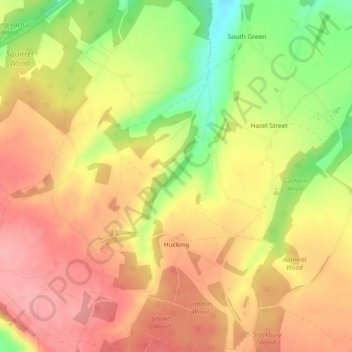
Name: Hucking topographic map, elevation, terrain.

Location: Hucking, Maidstone, Kent, England, United Kingdom (51.28504 0.61441 51.31370 0.65699)

Average elevation: 153 m

Minimum elevation: 85 m

Maximum elevation: 196 m

Other topographic maps

Click on a map to view its topography, its elevation and its terrain.

Mote Park

United Kingdom > England > Kent > Maidstone > Otham

Average elevation: 52 m

Westfield Sole

United Kingdom > England > Kent > Maidstone

Average elevation: 145 m

Gear up for your next adventure:

🥤Collapsible Travel Cup - Saves space and weight in your mess kit
🔭Compact Binoculars - Lightweight optics for scouting trails and wildlife
💡Portable Camping Lamp - Rechargeable lamp for campsite lighting
🧢Sun Protection Cap - Breathable cap to protect from sun exposure
🥾Mountain Trail Shoes - High-traction shoes for mountain trails

As an Amazon Associate, this site earns from qualifying purchases at no extra cost to you.