
Maasmechelen topographic map
Interactive map
Click on the map to display elevation.
About this map
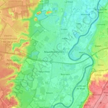
Name: Maasmechelen topographic map, elevation, terrain.
Location: Maasmechelen, Tongres, Limbourg, Belgique (50.91037 5.59532 51.01227 5.76767)
Average elevation: 57 m
Minimum elevation: 28 m
Maximum elevation: 119 m
Other topographic maps
Click on a map to view its topography, its elevation and its terrain.
Fouron-Saint-Pierre
Fouron-Saint-Pierre, Fourons, Tongres, Limbourg, Flandre, 3792, Belgique
Average elevation: 214 m
Kleine-Spouwen
Belgique > Limbourg > Tongres > Bilzen
Kleine-Spouwen, Bilzen, Tongres, Limbourg, Flandre, Belgique
Average elevation: 97 m