
Make a donation
Gear up for your next adventure:
As an Amazon Associate, this site earns from qualifying purchases at no extra cost to you.
Knapps Corner topographic map
Click on the map to display elevation.
Make a donation
Gear up for your next adventure:
As an Amazon Associate, this site earns from qualifying purchases at no extra cost to you.
About this map
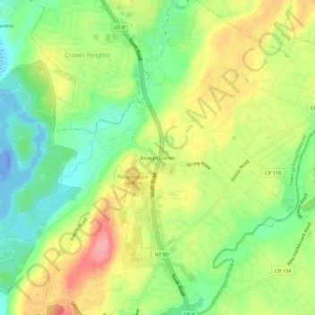
Name: Knapps Corner topographic map, elevation, terrain.
Average elevation: 48 m
Minimum elevation: -43 m
Maximum elevation: 107 m
Make a donation
Gear up for your next adventure:
As an Amazon Associate, this site earns from qualifying purchases at no extra cost to you.
Other topographic maps
Click on a map to view its topography, its elevation and its terrain.
Rhinecliff
United States > New York > Dutchess County > Town of Rhinebeck
The hamlet is demarcated by large agricultural and wooded area to the north, east, and south, and bounded by the Hudson River on the west. Steep topography, formed by contorted slate ridges and valleys, define the site-specific and seemingly random orientation of the small, frame nineteenth-century houses and…
Average elevation: 19 m
Make a donation
Gear up for your next adventure:
As an Amazon Associate, this site earns from qualifying purchases at no extra cost to you.
Drayton Grant Park at Burger Hill
United States > New York > Dutchess County > Town of Rhinebeck
Average elevation: 102 m
Make a donation
Gear up for your next adventure:
As an Amazon Associate, this site earns from qualifying purchases at no extra cost to you.
Stissing Mountain Multiple Use Area
United States > New York > Dutchess County > Town of Pine Plains
Average elevation: 217 m
Alamar Unit
United States > New York > Dutchess County > Town of East Fishkill
Average elevation: 278 m
Make a donation
Gear up for your next adventure:
As an Amazon Associate, this site earns from qualifying purchases at no extra cost to you.
Make a donation
Gear up for your next adventure:
As an Amazon Associate, this site earns from qualifying purchases at no extra cost to you.
United States of America Property
United States > New York > Dutchess County > Village of Pawling
Average elevation: 251 m
Make a donation
Gear up for your next adventure:
As an Amazon Associate, this site earns from qualifying purchases at no extra cost to you.
Make a donation
Gear up for your next adventure:
As an Amazon Associate, this site earns from qualifying purchases at no extra cost to you.
Salt Point
United States > New York > Dutchess County > Town of Pleasant Valley
Average elevation: 97 m