
Municipio de San Salvador de Jujuy topographic map
Interactive map
Click on the map to display elevation.
Municipio de San Salvador de Jujuy
Jujuy has a humid subtropical climate (Cwa, according to the Köppen climate classification), mainly because of the altitude. Summers bring warm days at 28 °C (82 °F) and nights at 16 °C (61 °F) with frequent thunderstorms. The rest of the year is sunny, with temperatures at about 24 °C (75 °F) during the day and 11 °C (52 °F) at night, crisp, dry winters with warm days of 19 °C (66 °F) and cold nights at 6 °C (43 °F), and sunny springs with warm days at 26 °C (79 °F) and cool nights at 11 °C (52 °F). During heat waves, temperatures can sometimes reach 35 °C (95 °F) but these are not frequent and nights always bring significant cooling, as opposed to many low-lying areas in Northern Argentina. During the winter, the record low has fallen to −7 °C (19 °F). Precipitation is about 800 mm (31 in), which falls in the form of thunderstorms during the warmest months. The highest temperature recorded was 42 °C (108 °F) on October 16, 2014 while the lowest temperature recorded was −6.9 °C (19.6 °F) on August 14, 1978.
About this map
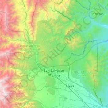
Name: Municipio de San Salvador de Jujuy topographic map, elevation, terrain.
Average elevation: 1,913 m
Minimum elevation: 732 m
Maximum elevation: 5,166 m
Other topographic maps
Click on a map to view its topography, its elevation and its terrain.