Geolocate

Macon topographic map

Click on the map to display elevation.

About this map

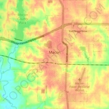
Name: Macon topographic map, elevation, terrain.

Location: Macon, Macon County, Missouri, 63552, United States (39.71586 -92.50087 39.76648 -92.44127)

Average elevation: 255 m

Minimum elevation: 225 m

Maximum elevation: 273 m

Other topographic maps

Click on a map to view its topography, its elevation and its terrain.

Bloomington

United States > Missouri > Macon County

Average elevation: 251 m

College Mound

United States > Missouri > Macon County

Average elevation: 248 m

Sue City

United States > Missouri > Macon County

Average elevation: 255 m

Laplata Lake Dam

United States > Missouri > Macon County

Average elevation: 277 m

Gear up for your next adventure:

🧼Travel Hand Sanitizer - Keep hands clean when water is scarce
🧰Survival Kit - Essential gear for emergencies in the wilderness
Backpacking Tent - Lightweight tent for long-distance hiking trips
🥾Waterproof Hiking Shoes - Durable shoes for wet and rugged trails
🍽️Titanium Camping Spork - Ultralight and indestructible eating utensil

As an Amazon Associate, this site earns from qualifying purchases at no extra cost to you.