
Charlotte Amalie West topographic map
Interactive map
Click on the map to display elevation.
About this map
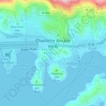
Name: Charlotte Amalie West topographic map, elevation, terrain.
Average elevation: 40 m
Minimum elevation: -1 m
Maximum elevation: 295 m
Other topographic maps
Click on a map to view its topography, its elevation and its terrain.
Saint John
United States > United States Virgin Islands > Saint Thomas - Saint John District > Coral Harbour
Saint John, Coral Harbour, Saint Thomas - Saint John District, United States Virgin Islands, United States
Average elevation: 26 m