Geolocate

Capps topographic map

Click on the map to display elevation.

About this map

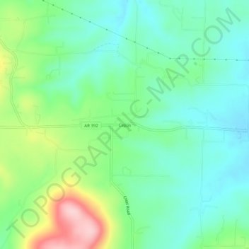
Name: Capps topographic map, elevation, terrain.

Location: Capps, Boone County, Arkansas, United States (36.21563 -93.20935 36.25563 -93.16935)

Average elevation: 434 m

Minimum elevation: 373 m

Maximum elevation: 579 m

Other topographic maps

Click on a map to view its topography, its elevation and its terrain.

South Lead Hill

United States > Arkansas > Boone County

Average elevation: 243 m

Valley Springs

United States > Arkansas > Boone County

Average elevation: 345 m

Zinc

United States > Arkansas > Boone County

Zinc is in the Ozark region and has an elevation of 879 feet (268 m).

Average elevation: 324 m

Diamond City

United States > Arkansas > Boone County

Average elevation: 223 m

Everton

United States > Arkansas > Boone County

Average elevation: 292 m

Alpena

United States > Arkansas > Boone County

Average elevation: 373 m

Gear up for your next adventure:

🧊Insulated Water Bottle - Keeps drinks cold in summer and prevents freezing in winter
🥾Hiking Shorts - Breathable shorts suitable for summer hikes
🛶Kayak Accessories - Essential gear for safe and fun kayaking adventures
🧥Waterproof Hiking Jacket - Protect yourself from rain and wind while hiking
🏃Hydration Running Vest - Carry water and maps close to your body for speed

As an Amazon Associate, this site earns from qualifying purchases at no extra cost to you.