
Lugueros topographic map
Interactive map
Click on the map to display elevation.
About this map
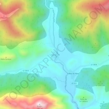
Name: Lugueros topographic map, elevation, terrain.
Location: Lugueros, Valdelugueros, León, Castilla y León, España (42.95312 -5.43239 42.99312 -5.39239)
Average elevation: 1,394 m
Minimum elevation: 1,156 m
Maximum elevation: 1,938 m
Está situado en el norte de la provincia, en la cordillera Cantábrica, a orillas del río Curueño y al NE de la peña Bodón (1998 m), a 1200 m de altitud, en la ruta que recorre el Curueño para dirigirse al Puerto de la Vegarada.
Other topographic maps
Click on a map to view its topography, its elevation and its terrain.
Valdelugueros
España > Castilla y León > Valdelugueros
Valdelugueros, Montaña de Riaño, León, Castilla y León, España
Average elevation: 1,516 m