Geolocate

Buga topographic map

Click on the map to display elevation.

About this map

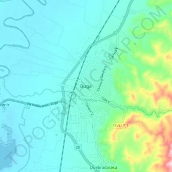
Name: Buga topographic map, elevation, terrain.

Location: Buga, Centro, Valle del Cauca, 762001, Colombia (3.86006 -76.34201 3.94006 -76.26201)

Average elevation: 999 m

Minimum elevation: 922 m

Maximum elevation: 1,363 m

Gear up for your next adventure:

🥾Waterproof Hiking Boots - Boots keeping your feet dry in wet conditions
🧭Orienteering Kit - Tools for map reading and navigation in the wild
🧥Thermal Layer - Insulating layer for cold outdoor conditions
🥾Mountain Trail Shoes - High-traction shoes for mountain trails
🥾Approach Boots - Comfortable boots for hiking and climbing approaches

As an Amazon Associate, this site earns from qualifying purchases at no extra cost to you.