Geolocate

Randall topographic map

Click on the map to display elevation.

About this map

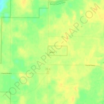
Name: Randall topographic map, elevation, terrain.

Location: Randall, Town of Anderson, Burnett County, Wisconsin, United States (45.67579 -92.85521 45.71579 -92.81521)

Average elevation: 272 m

Minimum elevation: 255 m

Maximum elevation: 281 m

Other topographic maps

Click on a map to view its topography, its elevation and its terrain.

Ann Lake

United States > Wisconsin > Burnett County

Average elevation: 303 m

Fawn Lake

United States > Wisconsin > Burnett County

Average elevation: 301 m

Devils Lake

United States > Wisconsin > Burnett County

Average elevation: 298 m

No Man's Lake

United States > Wisconsin > Burnett County

Average elevation: 313 m

Gear up for your next adventure:

👟Sport Hiking Sandals - Breathable footwear for water crossings and camp rest
🧭GPS Tracker - Track your location in remote areas safely
🥫Freeze-Dried Meals - Lightweight, high-calorie nutrition for multi-day treks
Backpacking Tent - Lightweight tent for long-distance hiking trips
📷Outdoor Action Camera - Capture high-elevation views and rugged adventures

As an Amazon Associate, this site earns from qualifying purchases at no extra cost to you.