
Make a donation
Gear up for your next adventure:
As an Amazon Associate, this site earns from qualifying purchases at no extra cost to you.
Piraeus topographic map
Click on the map to display elevation.
Make a donation
Gear up for your next adventure:
As an Amazon Associate, this site earns from qualifying purchases at no extra cost to you.
About this map
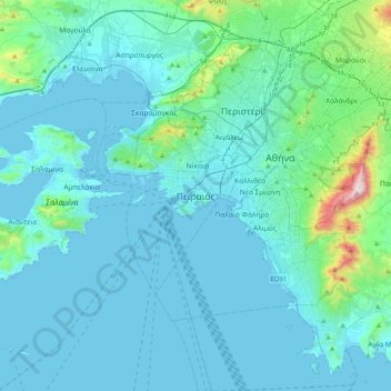
Name: Piraeus topographic map, elevation, terrain.
Average elevation: 96 m
Minimum elevation: -3 m
Maximum elevation: 1,018 m
Make a donation
Gear up for your next adventure:
As an Amazon Associate, this site earns from qualifying purchases at no extra cost to you.
Other topographic maps
Click on a map to view its topography, its elevation and its terrain.
Municipality of Nikaia-Agios Ioannis Rentis
Greece > Attica > Regional Unit of Piraeus
Average elevation: 53 m
Municipality of Nikaia-Agios Ioannis Rentis
Greece > Attica > Regional Unit of Piraeus
Average elevation: 53 m
Make a donation
Gear up for your next adventure:
As an Amazon Associate, this site earns from qualifying purchases at no extra cost to you.
Make a donation
Gear up for your next adventure:
As an Amazon Associate, this site earns from qualifying purchases at no extra cost to you.
Λιμένας Λέοντος
Greece > Attica > Regional Unit of Piraeus > Piraeus > Δραπετσώνα
Average elevation: 12 m