Geolocate

Kissing topographic map

Click on the map to display elevation.

About this map

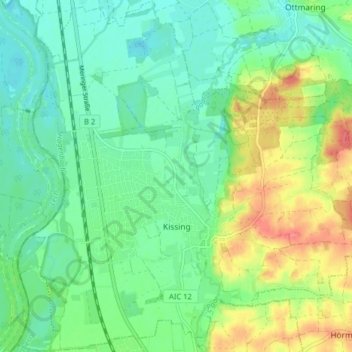
Name: Kissing topographic map, elevation, terrain.

Location: Kissing, Landkreis Aichach-Friedberg, Bavaria, 86438, Germany (48.28005 10.94425 48.33316 11.02441)

Average elevation: 507 m

Minimum elevation: 484 m

Maximum elevation: 552 m

Other topographic maps

Click on a map to view its topography, its elevation and its terrain.

Pichl

Germany > Bavaria > Landkreis Aichach-Friedberg

Average elevation: 477 m

Lindl

Germany > Bavaria > Landkreis Aichach-Friedberg

Average elevation: 489 m

Gear up for your next adventure:

🧥Waterproof Jacket - Lightweight rain jackets for hiking and outdoor activities
🛶Canoe Life Vest - Safety vest for water sports
Camping Groundsheet - Protect your tent from moisture and dirt
🧤Insulated Winter Gloves - Heavy-duty protection for sub-zero Canadian adventures
🧰Survival Kit - Essential gear for emergencies in the wilderness

As an Amazon Associate, this site earns from qualifying purchases at no extra cost to you.