
Gardner topographic map
Click on the map to display elevation.
Gardner
According to the United States Census Bureau, Gardner has a total area of 23.0 square miles (60 km2), of which 22.2 square miles (57 km2) is land and 0.8 square miles (2.1 km2), or 3.52%, is water. The city is situated on Crystal Lake. Its highest point is the summit of Reservoir Hill, close to the city center, with an elevation of over 1,280 feet (390 m) above sea level.
About this map
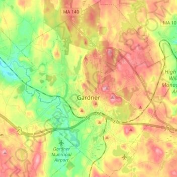
Name: Gardner topographic map, elevation, terrain.
Average elevation: 326 m
Minimum elevation: 259 m
Maximum elevation: 391 m
Other topographic maps
Click on a map to view its topography, its elevation and its terrain.
South Barre
United States > Massachusetts > Worcester County > Barre > South Barre
Average elevation: 223 m