
Make a donation
Gear up for your next adventure:
As an Amazon Associate, this site earns from qualifying purchases at no extra cost to you.
Oberwiesenthal topographic map
Click on the map to display elevation.
Make a donation
Gear up for your next adventure:
As an Amazon Associate, this site earns from qualifying purchases at no extra cost to you.
Oberwiesenthal
Oberwiesenthal lies in the county of Erzgebirgskreis, on the border with the Czech Republic that follows the course of the Pöhlbach stream as far as Bärenstein (10 km northeast). The highest elevation in the borough is the Fichtelberg (sometimes called the Großer Fichtelberg or Great Fichtelberg) which, at 1,215 m above NN, is the highest mountain in Saxony.
Make a donation
Gear up for your next adventure:
As an Amazon Associate, this site earns from qualifying purchases at no extra cost to you.
About this map
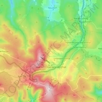
Name: Oberwiesenthal topographic map, elevation, terrain.
Location: Oberwiesenthal, Erzgebirgskreis, Saxony, 09484, Germany (50.40402 12.85948 50.46706 13.02269)
Average elevation: 928 m
Minimum elevation: 677 m
Maximum elevation: 1,249 m
Make a donation
Gear up for your next adventure:
As an Amazon Associate, this site earns from qualifying purchases at no extra cost to you.