
Make a donation
Gear up for your next adventure:
As an Amazon Associate, this site earns from qualifying purchases at no extra cost to you.
La Gaudinais topographic map
Click on the map to display elevation.
Make a donation
Gear up for your next adventure:
As an Amazon Associate, this site earns from qualifying purchases at no extra cost to you.
About this map
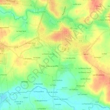
Name: La Gaudinais topographic map, elevation, terrain.
Average elevation: 51 m
Minimum elevation: 25 m
Maximum elevation: 76 m
Make a donation
Gear up for your next adventure:
As an Amazon Associate, this site earns from qualifying purchases at no extra cost to you.
Other topographic maps
Click on a map to view its topography, its elevation and its terrain.
Saint-Aubin-du-Pavail
France > Bretagne > Ille-et-Vilaine > Châteaugiron
Saint-Aubin-du-Pavail est à une altitude de 59 mètres. La commune est située dans le Pays de Rennes, à 20 km au sud-est de la capitale bretonne. Elle est bordée par plusieurs communes : Ossé au nord (à 1,2 km), Châteaugiron à l'ouest (à 2,4 km), Piré-sur-Seiche au sud (à 6,0 km), et Domagné à…
Average elevation: 59 m