Geolocate

Napel topographic map

Click on the map to display elevation.

About this map

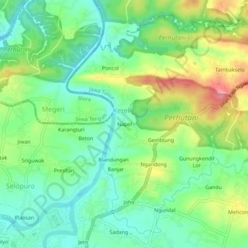
Name: Napel topographic map, elevation, terrain.

Location: Napel, Kerek, Ngawi, East Java, Java, 63211, Indonesia (-7.39498 111.44607 -7.35498 111.48607)

Average elevation: 70 m

Minimum elevation: 32 m

Maximum elevation: 137 m

Gear up for your next adventure:

🧥Thermal Layer - Insulating layer for cold outdoor conditions
🛌Down Sleeping Bag - Superior warmth-to-weight ratio for cold nights
🥾Waterproof Trail Shoes - Shoes designed to handle wet terrain
Camping Essentials - All-in-one gear for a comfortable camping trip
🥾Approach Shoes - Shoes designed for climbing approaches and rugged trails

As an Amazon Associate, this site earns from qualifying purchases at no extra cost to you.