Geolocate

Assisi topographic map

Click on the map to display elevation.

About this map

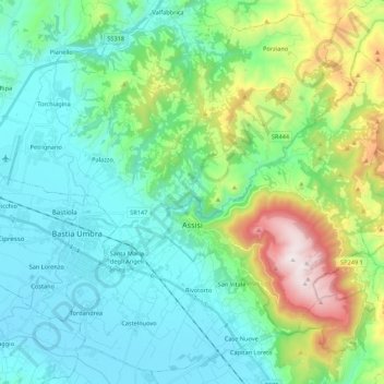
Name: Assisi topographic map, elevation, terrain.

Location: Assisi, Perugia, Umbria, 06081, Italy (43.01078 12.51072 43.15870 12.72712)

Average elevation: 436 m

Minimum elevation: 179 m

Maximum elevation: 1,286 m

Other topographic maps

Click on a map to view its topography, its elevation and its terrain.

San Pietro

Italy > Umbria > Perugia > Corciano

Average elevation: 264 m

Gear up for your next adventure:

🧦Hiking Liner Socks - Thin base layer to prevent friction and blisters
🚑Survival Whistle - Signal for help across long distances in mountains
🧥Waterproof Hiking Jacket - Protect yourself from rain and wind while hiking
🧥Insulated Jacket - Keep warm in cold outdoor conditions
🥾Light Trekking Boots - Supportive boots for multi-day treks

As an Amazon Associate, this site earns from qualifying purchases at no extra cost to you.