
Make a donation
Gear up for your next adventure:
As an Amazon Associate, this site earns from qualifying purchases at no extra cost to you.
Punata topographic map
Click on the map to display elevation.
Make a donation
Gear up for your next adventure:
As an Amazon Associate, this site earns from qualifying purchases at no extra cost to you.
Punata
The region of Punata, at the upper end of the Valle Alto, at about 2800 m altitude, has a summer rainfall of 400 to 450 mm starting in the second half of November end ending in March. Maize is here the most important food crop, followed by potatoes. Alfalfa is the dominant fodder crop, followed by maize straw. (Fig. P1). These crops could, of old, only be planted successfully because of the existence of additional water resources like runoff, floods, river base-flow and groundwater. In the winter months, crop growth is restricted due to the occurrence of night frosts, especially in June and July, and absence of rains.
Make a donation
Gear up for your next adventure:
As an Amazon Associate, this site earns from qualifying purchases at no extra cost to you.
About this map
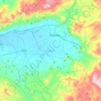
Name: Punata topographic map, elevation, terrain.
Location: Punata, Cochabamba, Bolivia (-17.74642 -65.95265 -17.43826 -65.71491)
Average elevation: 3,077 m
Minimum elevation: 2,693 m
Maximum elevation: 4,179 m
Make a donation
Gear up for your next adventure:
As an Amazon Associate, this site earns from qualifying purchases at no extra cost to you.
Other topographic maps
Click on a map to view its topography, its elevation and its terrain.